Author
ZIGURAT
Blog / BIM & Construction Management
Categories
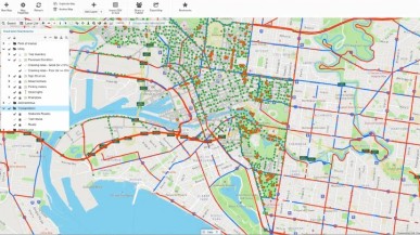
GIS, short for Geographic Information System, refers to a powerful software tool that captures, stores, analyzes, manages, and presents geospatial data. In the realm of civil engineering, GIS allows professionals to collect and leverage location-based information to make informed decisions throughout the project lifecycle. By integrating spatial data with non-spatial information, civil engineers can gain valuable insights into various aspects of their projects, leading to enhanced planning, design, and construction processes.
The integration of Global Positioning System (GPS) technology with GIS has revolutionized the field of civil engineering. GPS enables precise positioning and data collection by using satellites, while GIS adds a layer of spatial analysis and visualization to the acquired data. This combination empowers civil engineers to accurately map and model real-world features, such as terrain, infrastructure, and utilities. Whether it's surveying, mapping, or monitoring, the integration of GPS and GIS provides a powerful toolkit for civil engineering professionals.
The applications of GIS in civil engineering are vast and diverse. Let's explore a few key areas where GIS plays a significant role:
1 - Infrastructure Planning and Management: GIS allows civil engineers to effectively plan and manage infrastructure projects by visualizing and analyzing data related to land use, transportation networks, utility systems, and more. This spatially-enabled decision-making facilitates optimized designs, reduces project costs, and enhances sustainability.
2 - Environmental Engineering: GIS aids environmental engineers in assessing the impact of projects on the environment. By overlaying geospatial data on environmental factors such as topography, vegetation, and hydrology, professionals can identify potential risks, mitigate environmental impacts, and ensure compliance with regulations.
3 - Urban Planning: GIS assists urban planners in creating comprehensive models that consider various aspects of urban development, including population growth, transportation systems, zoning regulations, and social infrastructure. This enables the creation of sustainable and resilient cities that meet the needs of their residents.
Building Information Modeling (BIM) and GIS integration provide a powerful synergy for AECO professionals. BIM focuses on creating and managing digital representations of physical and functional characteristics of buildings, while GIS adds a spatial component to these models. By combining the information-rich BIM models with geospatial data, professionals can gain a holistic understanding of projects, optimize asset management, improve maintenance processes, and enhance facility operations.
Master's in Global BIM Management in Civil Engineering and GIS:
To stay ahead in the AECO industry, acquiring specialized knowledge in GIS and its integration with BIM is essential. The Master's in Global BIM Management in Civil Engineering and GIS program offers a unique opportunity to develop expertise in these cutting-edge technologies. By enrolling in this program, professionals can enhance their skill set, unlock new career opportunities, and become leaders in the field of AECO. The program covers a wide range of topics, including BIM Management, Data collection for Infrastructure Projects and GIS, BIM for infrastructure projects, Construction of infrastructure in BIM, Maintenance of infrastructure in BIM and practical applications in civil engineering. The main advantage is that you can choose your path: Railroad Design Model or Water supply network and Sanitary Sewer Design Model. Through hands-on participation, students develop essential skills in working collaboratively to produce deliverables for a real-world project as a Final Master's project.
As the AECO industry continues to embrace digital transformation, GIS has emerged as a game-changer for professionals in civil engineering and environmental engineering. The ability to leverage geospatial data, combined with tools like GPS and BIM integration, empowers engineers to make data-driven decisions, optimize project workflows, and create sustainable built environments. By enrolling in the Master's in Global BIM Management in Civil Engineering and GIS program, professionals can position themselves at the forefront of this technological revolution and drive innovation in their respective fields.
ZIGURAT