$94 trillion. That is the estimated global infrastructure investment required by 2040. Alongside this, other figures are equally striking: $500 billion lost annually due to urban congestion, recurring cost overruns in major projects, and more than $1.5 trillion lost due to poor data interoperability .
These numbers point to something difficult to ignore: urban mobility is not simply an operational challenge, but one of the defining strategic issues of our time. In this context, sustainable urban mobility can no longer be framed purely as an environmental objective. It sits at the intersection of economic performance, governance models, and decision-making capacity at scale.
For years, cities have attempted to respond through new infrastructure or incremental improvements in public transport systems. Yet the underlying constraint is not only physical. It is structural, and increasingly, it is data-related.
Urban systems, in most cases, still do not speak the same language. Traffic sensors, energy grids, logistics platforms, and public safety systems operate within disconnected environments. This fragmentation makes it difficult to construct a coherent, system-level view of the city and, as a consequence, limits any meaningful attempt at advanced urban mobility planning. Without interoperability, intelligence remains partial; and without that intelligence, sustainable mobility outcomes remain constrained.
Sustainable Urban Mobility and Digital Twin Smart City
This is where the concept of a smart citydigital twin becomes relevant, not as a visualization layer, but as an underlying data infrastructure.
A geospatially enabled digital twin allows previously disconnected systems to converge. When BIM integrates with GIS, and when IoT data is layered onto infrastructure networks, what emerges is not just a model, but a shared data environment through which the city can be interpreted as a dynamic system. It is precisely this layer that makes artificial intelligence operationally meaningful. Without it, AI models remain dependent on fragmented datasets, producing outputs that may be technically valid but strategically incomplete.
At this point, the discussion inevitably shifts from technology to governance. Data integration is not neutral. It requires decisions about ownership, access, interpretation, and use. The transition toward smart mobility systems is therefore not only technological, but institutional, relying on coordination between public agencies, infrastructure operators, and private stakeholders.
Cities that are advancing in this direction are not doing so by simply acquiring new tools. They are, more fundamentally, developing capabilities—building environments where interoperability supports both real-time operations and long-term sustainable urban mobility strategies.
Predictive Operations, Generative Design and Human-Centric Governance
The most immediate application of AI is prediction. When mobility data flows continuously into a digital twin, machine learning models identify patterns that are not easily visible to human operators. When will congestion emerge? Which assets are failing? How will weather conditions affect demand?
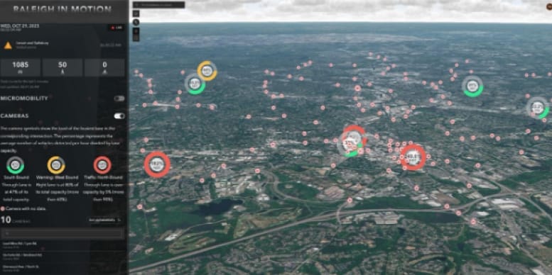
Raleigh, North Carolina: Partnering with Esri and NVIDIA, the city deployed AI-powered computer vision across its traffic network. The system achieves 95% vehicle detection accuracy, delivering analytics four times faster than manual methods. Result: an estimated $9.7 million in annual time and fuel savings for commuters.
Source: NVIDIA
The numbers reflect a broader trend. Smart mobility systems can reduce congestion by 20–30%, while organizations using AI-driven digital twins report capital expenditure reductions in the range of 15–20%.
What matters, however, is not the isolated case, but the pattern that emerges when data is continuously integrated. Prediction becomes proactive rather than reactive. Congestion is no longer something that is simply managed once it appears, but something that can be anticipated through simulation.
The second capability is strategic design. This is where AI moves from tactical to strategic. A digital twin becomes a simulation engine for investment decisions. Where should a transit corridor go? How will pedestrian flow affect retail revenue? What phasing maximizes ROI over 20 years?
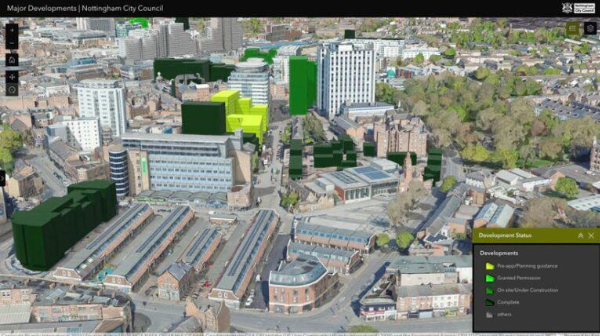
Nottingham, England: A 73-square-kilometer digital twin built with ArcGIS Urban helped transform post-industrial sites into a mixed-use community. The model secured £4 billion in investments. UK government analysis found £2 return for every £1 invested over a decade. The project is delivering 7,000+ new homes and 15,000 new jobs.
Source: Esri
From a financial perspective, the implications are non-trivial. Generative design can reduce project costs by 10–15%. At large program scale, this translates into billions in preserved value. AI enables a shift in where risk is absorbed—errors are addressed in simulation rather than in built infrastructure.
The third dimension, and arguably the most consequential, addresses the ultimate purpose of urban systems: serving people, and the economic imperative that follows. AI monitors crowd safety, measures quality-of-life indicators, and models social impact before decisions are locked in. Urban systems are not ends in themselves; they exist to support human activity and well-being, with direct economic implications.
Global Events Security: For World Cups and Olympics, GIS-enabled Security Operations Centres with digital twins provide real-time threat detection across jurisdictions. As Esri's homeland security experts note, "Security isn't static. Incidents escalate in seconds." AI provides the decision advantage.
Red Rocks Amphitheatre, Denver: First responders carry tablets with a high-precision digital twin. They simulate evacuations, locate hydrants, and assess terrain before arriving. For venues hosting thousands, this is AI-enabled situational awareness protecting what matters most.
The implications extend beyond safety. Cities that prioritize resilient infrastructure can avoid up to $1 trillion in annual economic losses. At the same time, quality-of-life metrics increasingly influence talent attraction, which in turn shapes long-term competitiveness.
Urban systems, therefore, cannot be reduced to performance indicators alone. Digital twins introduce a layer of intelligence that links operational efficiency with broader sustainable urban mobility outcomes and societal impact.
The Governance Model: From Reactive to Predictive
Traditional governance models are fundamentally reactive. A problem emerges, data is collected, analysis is conducted, and intervention follows, often with significant delay.
AI-enabled governance, built on interoperable digital twins, introduces a different logic:
Continuous sensing: real-time data streams into the twin
Pattern recognition: AI identifies anomalies and emerging trends
Scenario simulation: decision-makers test responses before implementation
Strategic intervention: actions are informed by simulated outcomes
Feedback and learning: results refine future predictions
The economic case is substantial. Digital transformation across infrastructure could unlock $3.7 trillion globally by 2030 through improved asset utilization and more efficient capital allocation (World Economic Forum).
AI augments the leader's capacity to see, understand, and decide.
This becomes particularly relevant in high-growth contexts such as Riyadh, where mobility systems are under sustained pressure and where urban mobility planning must align with long-term strategic agendas such as Saudi Vision 2030.
The opportunity is significant, but it also introduces a clear differentiation. Organizations that have already adopted these approaches report measurable improvements: reductions in capital expenditure, increased operational efficiency, and more informed decision-making processes.
Beyond metrics, however, the underlying shift is structural.
We stand at a threshold. The cities being built today will define how people live, move, and interact for decades. Their performance will depend not only on physical infrastructure, but on their capacity to adapt, to respond, and to anticipate.
For decision-makers, the implication is increasingly explicit: competitive advantage will depend on treating data as a strategic asset and artificial intelligence as a core capability. With $94 trillion being deployed, inertia is no longer a neutral position.
Early adopters are already reporting measurable gains and, more importantly, are establishing a different operating model.
Sustainable urban mobility will not be achieved through infrastructure expansion alone, but through better-informed decisions. Those decisions, in turn, depend on how effectively data is connected, governed, and transformed into actionable intelligence.
This is where the future of cities is being defined. And where interoperable digital twins are no longer supporting tools, but foundational infrastructure for more resilient, efficient, and sustainable urban systems.
H
Author
Hesham Gamal Gaafar
Alumnus of the Master’s in Smart Cities at ZIGURAT Institute of Technology
Hesham Gamal Gaafar is Manager of Digital Twin, Smart Cities & AEC at Esri Saudi Arabia. He is an MIT Sloan alumnus, TOGAF 10 certified, and holds an MBA. He is also an alumnus of the Master’s in Smart Cities at ZIGURAT Institute of Technology. His work focuses on AI-ready digital twins and the integration of emerging technologies for smart environments.